29 Oct 2016 Sat
It pays to reach the airport early. Due to the overbooking situation in the UA2 flight, R's family was upgraded to SQ which would depart 40 minutes later, whereas I will stay in the UA2 flight.
The 15 hour flight didn't feel as long. They served 2 meals and a snack in between meals. Passengers can go to the galley and get drinks and snacks. A short nap and I was already more than half way through. Watched Cleopatra, a 1963 movie to pass time.
Reached SFO in good sunny weather, still on 29 Oct 2016. Slight drizzle and saw rainbow at the domestic terminal while waiting for the flight to Phoenix.
 1
1 2
2Flight to Phoenix was smooth and punctual. I didn't have to check in my baggage and but have to demonstrate that I can fit my luggage into the cabin space by fitting it into a standing fit-test frame near boarding gate. If need to check in, each check-in luggage cost US25, no free check in luggage for United Airlines, unlike Southwest.
 3
3 4
4 5
5 6
6 7
7 8
8 9
9I took the shuttle to retrieve my car from Hertz. Gold member can skip the queue and go straight to the car. It was a Dodge Journey, a car that I had so much complains later.
Plus I should have taken the fuel prepay option cos I will be returning the car at San Francisco, and the fuel there are more expensive than Phoenix. Lesson learnt.
I actually went up to the Hertz guy and complained that the front car plate of my rental car has dropped off. He looked at me in disbelief and said that there was no front car plates for cars registered in Arizona, rear plate suffice. Lol.
I lost my way the moment I came out from the airport. I went to an office building and asked the gentleman how to get on I-17. He was kind enough to explain the way to me. Once I got on the highway, it was through many high elevations before I got to I-40. Here I got lost again at Flagstaff. After awhile I figured out the way to go back to I-40 and the road to Grand Canyon appeared. I missed the sunset at Grand Canyon. There was a drizzle and rainbow appeared while I was driving towards the Grand Canyon.
I turned around at Tusayan, a small town before entering Grand Canyon since the sky was already dark. By the time i reach Williams it was 8pm. I checked into Motel 6 and went to Safeway opposite to buy food.
Williams is the starting point of Grand Canyon Railway. Tourists came here to take the steam-engine train that will bring them into Grand Canyon National Park. Little did i know that the freight trains also passed by Williams in the middle of the night and I got woken up 2 times due to the horns.
30 Oct 2016 Sun
I went out at 445am the next day to see sunrise at Grand Canyon. It was an hour drive to the Grand Canyon visitor centre. It was so early that there was no one manning the fee collection booth. Since I have the National Park Annual Pass (bought from Carousell), I went straight to the car park. The shuttle bus for Yaki Point came and pick us up at around 6am. I reached Yaki Point just in time for the sunrise. The sun illuminated the clouds to a fiery crown, very impressive. The whole canyon was lit up by the sun. Finally I got to see the Grand Canyon. Got to know another photographer from Guangzhou here, who stay inside the park. He took the Milky Way and star trails photos last night. The photos looked very impressive. We exchanged contacts.
 10
10 11
11 12
12 13
13 14
14 15
15 16
16 17
17 18
18 19
19 20
20 21
21 22
22 23
23 24
24 25
25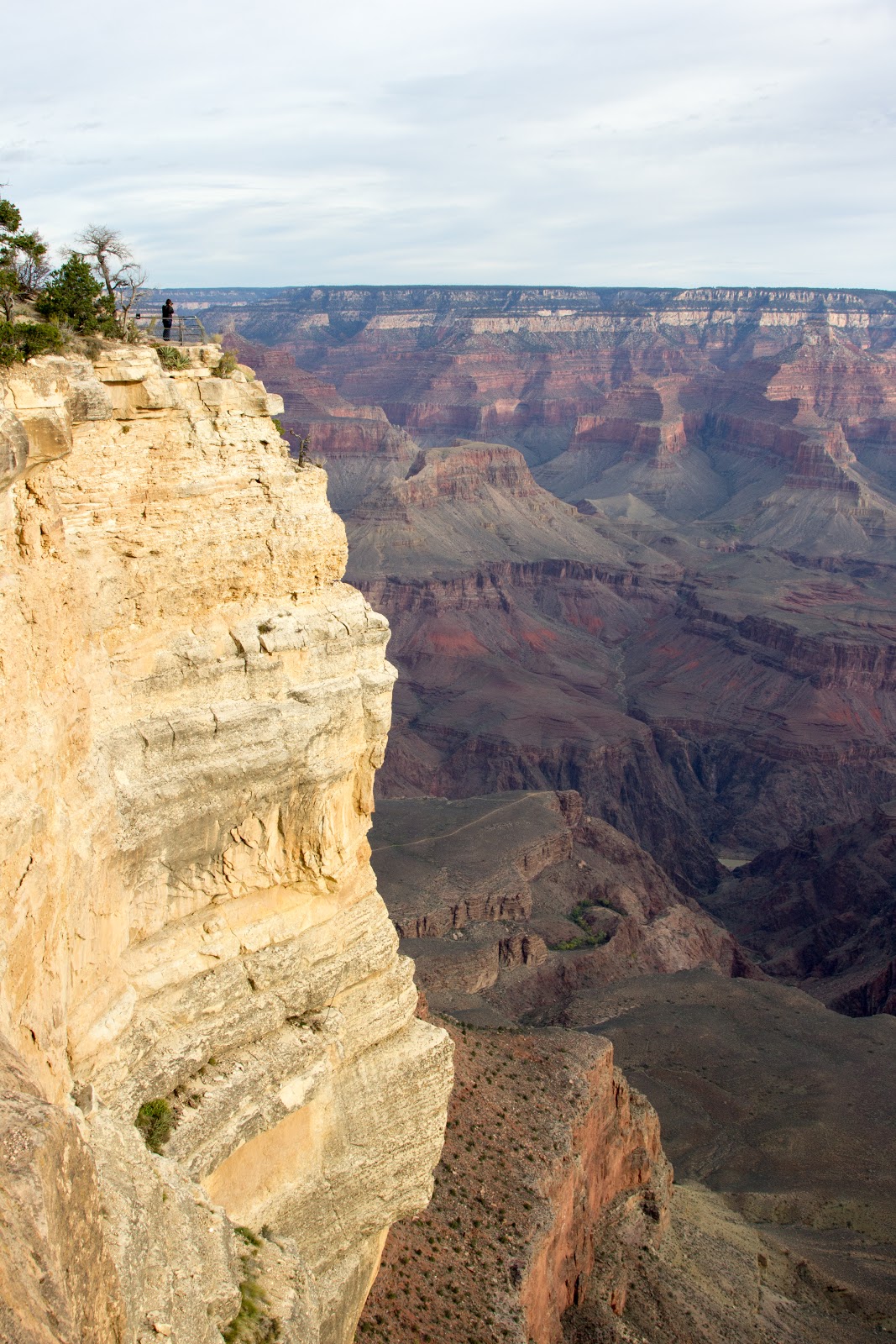 26
26I took the shuttle bus back to the Visitor Centre to get stamps on my passport. Apparently hiking down and camping at the canyon is possible, but prior reservation and permit application must be made.
I took another shuttle to see the Grand Canyon from another point. There was a artist sitting at the edge of the protruding platform and doing painting on Grand Canyon. He is one dare devil.
 27
27 28
28 29
29At around 930am, I started to drive to Page to visit Antelope Canyons. The upper Antelope Canyon was more popular and hence the tickets were more expensive. I chosed to do a photography tour with the Lower Antelope Canyon instead. The drive to the Antelope Canyon was quite interesting especially the last part. You gotto drive uphill and there was one part I was driving through two narrow vertical cliff.
 30
30 Annual pass are not honoured in Antelope Canyons as they are privately managed by the Navajo (native) people. There are no water at the tour office so going to the toilet was a bit of a hassle.
 31
31 At 1230pm, our photographic guide Shane brought me and another Chinese family down to the canyon for photography. The chinese family were from Guangzhou too, but stay in San Francisco currently. If you join the Photography tours, you are allowed to bring tripod with you. We started snapping pictures away the moment we descend down the canyon through rather steep staircase.
 32
32  33
33 34
34 35
35 36
36 37
37 The lips:
 38
38 The shark's jaw:
 39
39The eyes:
 40
40 41
41 42
42 43
43 44
44 45
45 46
46 47
47 The canyons were crafted by the rain water that seeps into the canyon and flow through it. We took many photos inside the canyon. 2 hours seemed too short for us.
 48
48 49
49After we finished our tour, i drove to Monument Valley. It was already near sunset. Heart attack when the gas left only 1/4 and no gas station within sight. When i drove past the place where Forrest Gump was doing his run, many people were taking photos but I dare not stop as looking for gas station was more urgent a task. Finally found a Shell station that had more expensive price - no choice anyway. Pumped petrol to full level at that station. There was a brief moment where the sunset was shining at the mountain near the gas station and gave it a beautiful glow. I took some pictures.
 50
50 51
51 52
52 53
53 54
54 55
55 56
56 The driving from the gas station to Bluff was a adrenaline pumping affair. Downhill at 6%, then 8%. I was careful not to press the brakes too frequent and too hard. I soon learnt that this kind of downhill-heart-racing episode will happen daily.
Once I have reached Bluff I made a right turn to road 162 East, and the sky was completely dark. Very few cars driving on that road. I made a wrong turn mid way and wasted sometime on turning back to the original path. I have decided to use the Gmap on my phone as a road guide instead of the paper map printout. It was much easier from here on.
Finally reached Cortez, a slightly bigger town along route 160 to Durango. I happened to passby a Chinese Restaurant and stop by to order take away dinner. The 2 ladies there were very kind. They advised me to drive carefully from Cortez to Durango as this last stretch was very mountainous. Occasionally elks might cross the roads. They also advised me to tap the brakes lightly as their father's car ever billow smoke due to continuous pressing on brakes when go downhill first time. I thanked them for their advice and drove off. Finally reached Durango at 11pm. The keys to my motel room were pasted at the office door. I took the key and entered my room to have my dinner. It was a long day, setting off at 445am and cross from Arizona to Utah to Colorado. One hour time zone crossed.
31 Oct 2016 Mon
Durango was the starting point of Million Dollar Highway. Here is a description of this dangerous road. The elevation changed from 6000 ft to 13000 ft, and the road has no guardrails.
http://www.dangerousroads.org/north-america/usa/635-million-dollar-highway-usa.html
 57
57 58
58 59
59 60
60 61
61 62
62 63
63Durango is also the starting point of the railway that run to Silverton. The railway was built to transport minerals last time. Durango, Silverton, Ridgway, Telluride, Ouray were all mining towns last time. They have hot springs also. The hot spring at Ouray has no sulphur smell. Ridgway was spelled as it is, no spelling error.
 64
64 65
65 66
66There were still fall colours as seen in this small little towns. I stopped to take pictures of the colourful trees along the way. There are scenic viewpoints to see the towns from high vantage points as well. The car lacked the acceleration to climb the mountains.
 67
67 Once I reached Silverton, I started to look for the entrance point to the unpaved road to Ice Lake trailhead. There was another couple preparing to hike to Ice Lake. I asked them if I could join them, but they hinted to me that they are fast hikers and I should start earlier while they were having breakfasts as the hike was tough.
I went to a few wrong turns before realising that I should always stick to the main path. The path was not very well-signed. I started to realise that i went into the wrong way when the road gets too difficult and too treacherous. The couple ever told me that even 4-year-old can do it, so it couldn't be too tough. That's when I started to be more alert and made better decisions whenever i came to some junctions.
The 4-mile hike was indeed tough. It took me 3 hours before I reach the high point to see the lakes. The couple overtook me when I was at the plateau just before the last section climb to the lake. The green and blue colour of the lakes were too surreal. I took some photos and didn't have the strength to traverse the mountain to see the Island Lake so I started walking down. Finally I met some hikers coming up. Most of the time I was alone at the route.
 68
68 69
69 70
70 The two hikers managed to catch up with me at the plateau, about 3/4 through the hike. They are good.
 71
71 Frozen dried stream that whitened the pebbles.
 72
72 Hiker going down. He was the only one I saw going down while we were heading up.
 73
73 74
74 75
75 76
76 The Ice Lake in Silverton:
 77
77 78
78 79
79 80
80 81
81 82
82 83
83 84
84 85
85Fire rainbow clouds, first saw it in Antarctica, now in Ice Lake. You can read more about it in this website: http://www.theeventchronicle.com/news/oceania/intense-fire-rainbow-clouds-light-up-the-sky-of-burketown-australia/# :
 86
86 87
87 88
88 89
89 There are quite a few peaks here above 14000ft elevation known as the 14ners. There are a total of 58 such peaks in Colorado, some of them in the Durango - Silverton San Juan mountain range.
http://www.durango.travel/activities/durango-14ers.htm
After I got back to my car at 240pm, it was another long drive to Colorado Springs today using the normal roads. I traverse quite a few mountains. Some of the mountains on both sides were so high that, the sun couldnt reach the valley below. There was one part where the trailer was negotiating the curves perched on the mountain like the Heineken advertisement.
 90
90 91
91 92
92 93
93 94
94 95
95 96
96 97
97 98
98 99
99 100
100 After pumping gas at Moltruse, I turn left to Road 50. The reservoirs in Blue Mesa was beautiful. Saw elk grazing by the roadside.
Finally reached my airbnb place for the night around 915pm. Andrew, one of the tenants of the house came out and brought me in.
1 Nov 2016 Tue
Halloween:
 101
101I woke up early to go around Colorado Springs to take some morning fall colours.
 102
102 103
103 104
104 105
105 106
106 107
107Pike's Peak:
 108
108 Pike's Peak was clear in the blue sky, too bad the train was not running that day. I was the first and onyl person joining the morning tour of Olympics Training Centre in Colorado Springs. This training centre is one of the 3 training centres, one in New York, one in San Diego and one in Colorado Springs. Colorado Springs has the advantage of being on high altitude and hence can prepare the atheletes to cope better with competition venues with high altitude.
Bob was my tour guide in the training centre. He gave me a VIP tour that normally cost 5 times more, many thanks to his effort in guiding me. This facility did not receive any federal funding, and solely rely on sponsors and visitors on funding.
They surprised me when they actually heard of Joseph Schooling won in the recent Olympics. I felt proud.
 108
108 109
109 110
110 111
111 112
112 113
113 A paraolympian and her poster at the glass window:
 114
114Pike's Peak:
 115
115My guide:
 116
116 117
117 118
118 119
119 120
120 121
121Squirrel:
 122
122 123
123 124
124After the tour, I drove to Aspen using the scenic route that I passed by last night in the dark. Finally I got to see the scenery in bright day light. I turn left into road 304 for a scenic lookout.
 125
125 126
126Scroll all the way to the right to see this panorama. You can see the town Buena Vista (Yes!) in the far end.
 127
127 According to Wikipedia, The Collegiate Peaks is a name given to a section of the Sawatch Range of the Rocky Mountains located in central Colorado. The Collegiate Peaks include some of the highest mountains in the Rockies. The section is so named because several of the mountains are named for prominent universities: Harvard, Princeton, Yale, Columbia, Oxford etc.
At Buena Vista (same town name as the town I stay in Singapore), I made a right turn towards Aspen, and had lunch at one of the chinese restaurant just by the side of the highway.
 128
128 129
129 Isabel, this is for you!:
 130
130 131
131 132
132 133
133The drive to Independence Pass was another round of switchbacks all the way above 12000ft, most times without guard rails (again!). It is the highest paved state highway over the Continental Divide in Colorado.
 134
134 135
135 136
136 137
137 138
138 139
139 140
140More information on Independence Pass and the Continental Divide in here:
https://www.codot.gov/projects/SH82/independence-pass/frequently-asked-questions.html
Several areas of the roadway can only accommodate a single car width so I had to follow the cars in front closely in order to pass those narrow sections. Trucks longer than 35ft are not allowed to use this road. The pass is closed during winter snowy months.
 141
141 142
142If those mountains in the San Juan are known as Fourteeners (elevation above 14000ft), the first named summit in this direction is Grizzly Peak, Colorado's highest thirteener.
Finally reached Aspen after heart-braking (car brakes) adrenalin pumping exercise. Drove straight to Maroon Bells for the afternoon. The visitor centre was already closed, so were the toilets (f*ck!). Some of the trees already dropped all their foliages. I didnt hike to Crater Lake (another lake higher up) because it was already near sunset time, and one must bring bear canister in order to proceed further. There were a few youngers who went ahead nonetheless but I have decided that I wont do it that day.
 143
143 144
144 145
145 There was a small privately owned animal feeding areas where i saw llamas. Not in Peru but Aspen, how cool was that?!
 146
146 I went to take a a look at the Aspen Recreational Centre. There was a football match going on. Everything in Aspen is expensive. Even a swim pass cost you 18.25, whereas in other parts of USA only cost $6.
 147
147 148
148 Fall colours:
 149
149 150
150 151
151 black-billed magpies:
 152
152 153
153 There are many villas for the skiiers perced on the hill either owned by the rich people or waiting to be rented out during the peak winter season. For a moment I thought I am in Switzerland. From the Recreation Centre, Maroon Bells can still be seen.
 154
154 I went to the Aspen Square hotel and faced the webcam, where my colleague in Senoko will video me from Singapore. Time in Aspen was 630pm, Singapore was 830am. We narrowly missed the colourful cam recording and only managed to get the black and white recording.
 155
155It was a low season in Aspen, only another guy Julius from Tenessee sharing a 6-bed dorm room with me. He was a Lithuanian. he was travelling alone this time as his wife ran out of vacation. He went to Maroon Bells this morning as well as the Crater Lake but found it dry.
Had my chicken pie microwaved in the kitchen and enjoyed it thoroughly.
Update: There was a rockfall at George Town and affected I70W, but I believe my journey from Aspen to Moab should not be affected even though Googlemap routed me using anothe route. I shall stick to my plan and ignore Googlemap.
2 Nov 2016 Wed
Woke up super early to see the sunrise in Maroon Bells. Since there was a drizzle in Aspen last night, Julius predicted that there will be snow in Maroon Bells, true enough. The trees branches were all iced up. It was such a big difference between yesterday and today. I was the first one there. It was freezing. I set up my tripod and waited for sunrise. The sun rose about 730am after a 1 hour wait. There were not many people in that area. Too early I guess.
 156
156 157
157 158
158 159
159 160
160 161
161 162
162 163
163 164
164 165
165 166
166 167
167 168
168 169
169 170
170 171
171 172
172 173
173 174
174 175
175 176
176 177
177 178
178 179
179 180
180 181
181 182
182 183
183Taking wedding photo:
 184
184 Wefie, photographer with the lucky couple. How they know its gonna snow today???
 185
185 186
186 187
187 188
188 189
189 190
190 191
191 192
192 193
193Driving out in the slightly icy road was challenging. I can hear the cracking sound when i open the car doors - the metals already started to stick after ice started to form and glue the door to the body. I kept swinging my steering wheel on my downhill drive out of Maroon Bells. Luckily there were no other cars/cyclists and I need not worry about other car users. The hills lining the main road had a layer of fresh snow on it.
Successfully drove out of Maroon Bells onto the main road, and saw traffic jams towards Aspen. Traffic jam!? I haven't seen it in a long while. Not in Colorado Springs, but in Aspen!
 194
194 195
195 Driving under morning sun was lovely. I made it out to I70W without any hiccups. Really appreciated my mobile phone as GPS. On I70W, saw a long freight train hauled by Santa Fe yellow locomotives. How cool is that.
Reached Grand Junction to pump petrol. Mr Brown passed by this town for a brief 25-minute break when he was on a California Zephyr from San Francisco to Chicago, on route to New York. His blog on Grand Junction stopover:
http://www.mrbrown.com/blog/2016/09/mrbrowns-great-us-train-adventure-day-23.html
Finally reached Arches National Park at around 130pm. This place was warm. From -10 degrees C in Aspen to more than 30 degrees C in Arches was....epic.
Had to drive 12 miles from the visitor centre to the trailhead for Delicate Arch. Then walk up about 1+ hour to reach the Delicate Arch, which was on the Utah car licence plate.
The arch was really majestic. They were not many people cos it was not yet sunset time. I couldn't wait till sunset as I still have to rush to the west, where I will stay for the night.
 196
196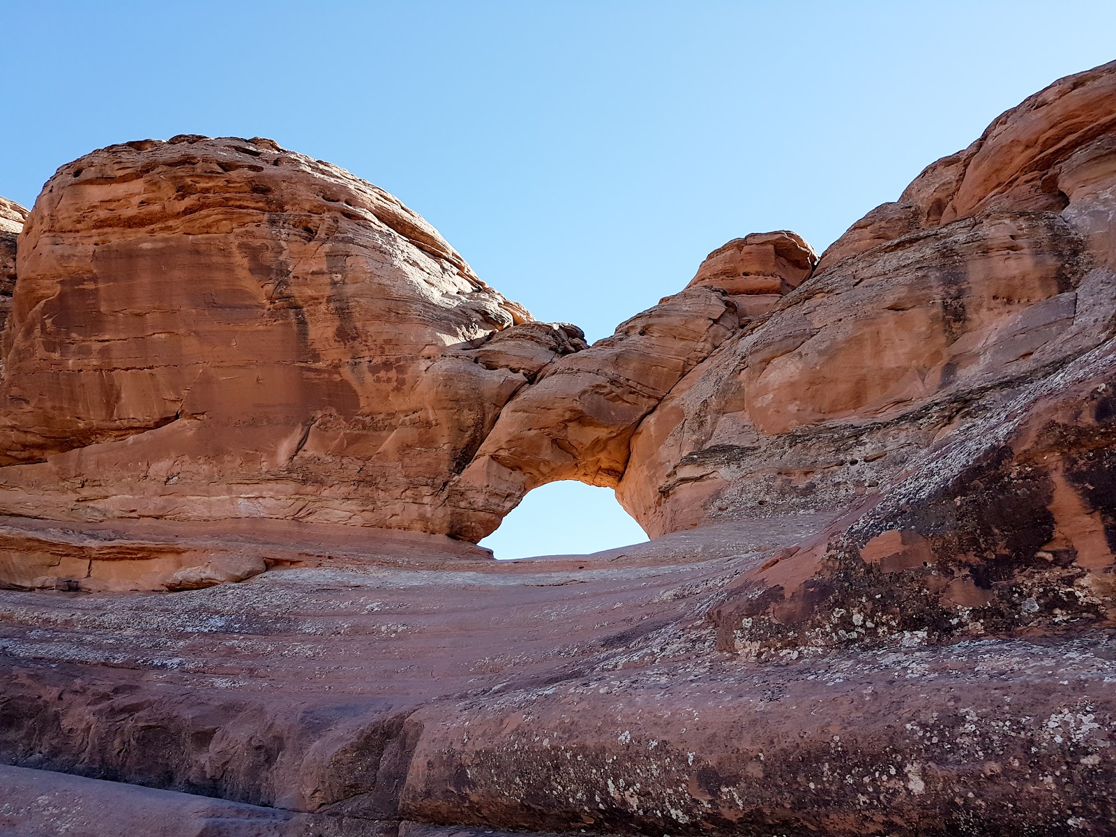 197
197 198
198 199
199 200
200 201
201 202
202 203
203 204
204 205
205 206
206 207
207 208
208 209
209 210
210 211
211 212
212The drive from Arches National Park to my next destination was eventful. First of all, there were no petrol stations for many miles, which means I couldnt go to toilet and my car was low on gas. When I was about to stop the car to piss in the middle of I70W, the scenic view point with toilet sign came out of nowhere and saved my embarrassment.
I have always thought I booked Days Inn in Kanab. I wanted to reach the place using I70W then I15S and I did. Little did I know I actually booked Days Inn in Hurricane actually. I could have turned into Kanab earlier from I70W earlier without going to I15S which I didn't cos I wanted to use the highway at night as much as possible. When the exit for Kanab appeared in I15S, I hesitated and took it anyway. Hence I have taken a longer route as this route go through the same mountains that I had taken when turning from I70W to I15S. When I finally reached Days Inn Kanab at 940pm and took out the hotel print out, I nearly fainted. Hurricane is only a short distance from I15S few exits down earlier had I didn't take the Kanab exit. There was totally no need to traverse the mountains that I took and save myself all the adrenalin pumping at nights in the mountain roads. In other words, I could have stayed on highway throughout this drive and need to go into mountain roads at all. If only I checked the booking page and key in the destination correctly in my Google Map app.
Another 1.5 hours of mountain roads and I finally reached Hurricane. This time round I was cautious and asked the gas station people where Days Inn Hurricane was. Finally got the right destination and managed to check in. This was my most depressed night as I wasted so much time on the road.
3 Nov 2016 Thu
There was cereal breakfasts provided by Days Inn. It was 40 minutes drive from Hurricane to Zion. Went to the visitor office to get my usual NPS Centennial stamp before taking the shuttle bus to the 4th station, The Grotto. This is the point where one can start walking to the highest viewing point in the canyon - Angel's Landing.
Description of the hike as quoted from the NPS website:
http://www.zionnational-park.com/zion-angels-landing-trail.htm
 213
213  214
214  215
215 Angels Landing and the West Rim Trail - From the Grotto Picnic area, cross the Zion Canyon Road. Head toward the footbridge that passes over the North Fork of the Virgin River. On the other side of the bridge, take the north (right) fork to the West Rim Trail. This busy path begins by traveling through a riparian woodland of cottonwood, pinyon pines and junipers. It's a steady 2 mile uphill trek as the trail ascends a series of switchbacks up the steep West Rim Trail. Much of the path hugs the side of the sun baked mountain offering an outstanding vista below of a shimmering river, billowy cottonwood trees and a rich collection of stone. A few ambitious trees are tenaciously growing in cracks high on the sheer cliff, adding bits of green between sections of rock that is stained by iron oxide and desert varnish.
Refrigerator Canyon - Just over one mile, hikers get a reprieve from the constant, steep grade of the West Rim Trail and the blazing heat of the full sun. The path turns toward a gap between Angels Landing and Cathedral Mountain. A cool breeze blows through the shady canyon leading to its name - Refrigerator Canyon. In the cooler climate of the ravine, vegetation is more abundant. The white fir is dominant, but it is the only place in the park where this is the case.
Squiggle the Wiggles - Just before the trail spills onto Scout Lookout, it's time to 'squiggle the wiggles,' as they ascend the steep twenty-one sharp zigzags to a scenic plateau. Walter's Wiggles was named after the first superintendent of Zion who helped engineer the steep zigzagging section. The park was in its planning stages at this time and the short, steep section of trail was created to enable horses to access Cabin Spring. One of his granddaughters works in Zion today and his home still stands in Springdale, known now as the Worthington Gallery.
Scout Lookout - The wiggles ascend to a broad, sandy area called Scout Lookout. This is the saddle at the junction of the Angels Landing Trail and the West Rim Trail. The views down into Zion Canyon are impressive. Several climbing routes can be viewed from this vantage point. West Rim Trail continues, past Cabin Spring to Lava Point in the Kolob Terrace section of Zion, but the Angels Landing Trail turns southeast.
Angels Landing Trail - Hikers will navigate the next half-mile along a narrow sandstone isthmus with sheer cliffs on both sides. The narrow and arduous trail drops 1200' on one side and 800' on the other. Chipmunks scurry carelessly along the ridge, finding bits of shade under the few trees that have found a weakness in which to burrow their roots. The summit offers I incomparable, fairy-tale views. Almost 1500' below, the Virgin River winds around the Organ. The Great White Throne seems only a stones throw away when standing at the end of the trail. Looking northeast across the canyon is Observation Point and to the east is Cable Mountain. Look closely to see the preserved cable-works structure on Cable Mountain. While exploring Zion in 1916, Frederick Fisher exclaimed, "only an angel could land on it," and thus the monolith was named Angels Landing.
When i was at Scout Lookout, I stashed my backpack near the picnic area and walked up the chained sections without a backpack. At a slightly higher point, I thought I reached Angel's Landing and started to chat and take photos with another lady, Jane. Jane's husband Jim told us off for mistaken this place where we took photos as Angel's Landing. Following his pointing finger, we finally saw that the Angel's Landing was till a long way up. Jim decided to stay at this point whereas the 2 of us continued to go up to the Angels' Landing, through another series of chain section on narrow stone steps. The grip between my boots and the sandstones were good, so it was not as scary as it seemed. My problem was more on hunger as I left my bag at the Scout's Lookout, I had to trek up without food. Jane asked one of those who came down to pass a word to her husband Jim, to encourage him to try the trail as well, as the trek was not as treacherous as we thought it was. There was even one couple who brought their baby up to the top, though i personally will not encourage it.
There were chipmunks running around in search of food remnants at the top. From Angel's Landing, one can see the famous bend, as well as the whole canyon.
 216
216  217
217  218
218 The baby was being fed, getting ready for the hike to the top.
 219
219 The bend, as seen from the top:
 220
220 221
221 222
222 Using chain to go up to Angel's Landing:
 223
223 224
224 Reached the top.
 225
225 Naughty chipmunks.
 226
226 227
227 The baby made it to the top!
 228
228 229
229 It was at this point that Jane told me she and her husband came from Aspen (surprise!) and she was originally from London. We went back down and saw her husband Jim struggled up. I told her that she should accompany her husband and I will wait for her at the Scout's Lookout.
Half an hour later, Jane returned with Jim, who had went up to Angel's Landing. I asked them where was their bag. It was at this point that Jane realised this is not the point we met, as we met slightly further up. Her husband Jim must have left the bag there after being persuaded by those who came down to try Angel's Landing. She quickly went back up to retrieve her bag.
On the way down, Jim told me his history. He actually enrolled in a Teacher's College and quitted school during Vietnam War. He went to Australia for 3 years. Then his younger brother and him went to jamaica and imported gem stones and made them into bracelets etc to sell in the USA and it was an instant hit. They made their first fortune and sold off the business 3 years later.
Shortly after, Jim went into yatch business with a Jamaica partner. At first, Jamaica was under communism, and the government was not friendly towards white businessmen like JIm. They asked for high price and fees in order for Jim to carry on his business and he of course refused to pay. Shortly after, Jamaica went into Capiltalist government, the government told him: you guys have created job, pay your dues, we will protect you and will not let other people come in and compete with you. Jim was granted 25 years of monopoly of yatch business together with this Jamaican partner. His partner is very good with engineering skills, so he could fix all kind of engine problems that the yatchs/catamarans have. The local staff are so happy working in the company, they even recommend their sons and daughters to come in and work for Jim. This is another success story that Jim has. It was also through the yatch business that the two get to know each other.
Jim has used some of the money to buy 70 acres of land using 420k USD. He sold the land away later on and made 4 times the profit. He was clever enough to retain the mineral rights of those land. Gas was found under their land. During the period of high oil price, many companies contacted Jim to get access to those gas. Jim asked one company and told them: if you want the gas, make me an offer so that the rest will back off. Double the highest price offered so far. The company did. The company told Jim that they will pay him and his younger brother 180. Jim asked, 180 what?! The company told them, 180k USD a month for the gas pumped out. The oil price went down after and the gas deal didnt take place but it is still good to know that they have that fortune waiting.
Jim is now retired and has owned Maseratti before. No wonder the couple stay in Aspen. I should have guessed.
Jane asked me if I am married and I just conveniently said yes, didnt know that our conversation topic and carry on from there. In email i confessed to her that I am actually still single and Jim will probably cane me if he knew that I lied (Jim always think that Singapore government is fond of caning people if they did anything wrong, and that was our joke for that day).
We gave each other a hug at the bus stop as they need to pick up their bike from the repair shop in town before returning to the lodge inside the national park. I will go opposite way to see any more interested stops further upstream. We saw rock climbers scaling the vertical cliff from the bus. Woos and aahs!
The last stop was the Narrows. I walked the walkway along Virgin River until a point where i saw many people left their shoes there. This is the beginning of the Narrows, where one walk inside the river gorges. I wasnt prepared so i could only take off my shoes and walk barefoot just to have a taste of river crossing - man, the water was freezing. There were many photographers taking photos on the river or by the side of the river.
 230
230 231
231 232
232 233
233 234
234 235
235 236
236 237
237 Took the bus out and it was near sunset, many photographers were admiring the sunset near Canyon Junction. I got down at this bus stop too and see The Watchmen changed colours under beautiful sunset. It was magical. I didnt bring my tripod since I was going to do Angel's Landing trail, a waste.

 238
238 239
239 240
240 241
241 242
242 243
243 244
244 245
245 246
246 247
247 It was almost the last bus out and I reached Hurricane at around 730pm.
There was a Chinese Buffet Restaurant near Hurricane. I was never a big fan of buffet as I couldnt eat much, but the dishes they have and the price convinced me to stay. I had good chat with Ah Le and his wife Quinnie during my dinner. They told me many interesting stories on how they survived in US as immigrants. They confessed that they had a much better income-expenditure ratio in US than in China. They have their fair share of stories to share with me. They couldnt understand why labour cost so much in US. The shop neon sign was not lighted up, the electrician came and inspect to see what was the problem, that itself cost US220, no repair done.
Another thing they found wierd was US hopsitals do not accept walk in. One must have GP's recommendation. The GPs and hospitals are all stingy with prescrition of medicine. Ah Le said one normally get well just by waiting for the doctor/hospital, which could be in months. Most of them ended up visiting chinese traditional doctors to get speedier fix. Ah Le ever down with lung infection and coughed for months, yet no medicine dispensed by the GP nor recommendation to visit the hospital. The GP simply dispensed some cough candies for him, which is of no use.
Food wise, they can only get food items from China from walmart in bigger cities like Las Vegas. In Hurricane, they could only go to Springs George for some limited items from China. If they order from Taobao, the shipping itself will take at least a month to reach them, by then the food items would have spoilt. US is well known to be a kid's heaven. Very little school work and short schooling hours.
I went back to Days' Inn for a dip in their hot water jacuzzi dip. it was a tad too warm for me.
4 Nov 2016 Fri
The next day i drove to Zion National Park again, and rented a pair of Neoprene socks, waterproof boots and waterproof pants from Outfitters. Barely 5 minutes walking on the Narrows, I lost my balance and fell. That fall didnt deter me and I continued on. After 2 hours of walk, only a few more people were still around me. The gorge got narrower. Due to time constraints, I had to turn back. I promise to explore further next time. I didnt feel the heat as the sun wont be able to shine in until past noon time.
 248
248 249
249 250
250 251
251 252
252 253
253 254
254 255
255 256
256 257
257 258
258 259
259 260
260 261
261 262
262 263
263 264
264 265
265 266
266 267
267I went back to China buffet for a late lunch before driving to Las Vegas. There was a traffic jam there as I travel through the town on I15S. The gas price in Las Vegas was outrageously high. I was hesitating whether to pump some gas at one gas station after LV and did it anyway. One more exit and I saw a gas station that was slightly cheaper. Damn. It is always a gamble between driving with 1/4 tank left and wait for the next exit or pump right away. Any gas station that shows 2.xx/gallon is good in my opinion.
Saw a sign that stop for hitch hikers are prohibited as there is a prison nearby north Las Vegas.
By the time I reach Barstow, the car clock showed 9pm. My Airbnb host was out (I was not even sure that's the house as there was no house number indicated, but my Google Map did show that was the correct location). Lucky I got my US sim card that I got from Carousell before I left, and started to call her. She didn't pick up but send me a sms that the house key was under the carpet. I went in and realised that it was only 8am. Argh! The one hour time difference between Utah and California. Since it is only 8pm, I could go and pack some Chinese food for dinner. So happened there was a Chinese take away nearby. As I entered the restaurant, all workers were angmo and they were packing up as closing time was 830pm.
Had a good night rest in this Airbnb.
5 Nov 2016 Sat
Drove off early from Barstow to San Francisco. Saw a very long freight train heading west.
 268
268There was jam in the Sacremento direction from every exit in the highway. I reached Mill Valley car park and met up with Laura. She drove me in her Subaru to Marin Headlands and Fort Point. It was a very clear day to capture photos of Golden Gate Bridge. Surfers were riding waves.
 269
269 270
270 271
271 272
272Seal:
 273
273 274
274 275
275 276
276 277
277 278
278 279
279 280
280 281
281 Same name as the bus station in Johor Bahru Malaysia:
 282
282 Laura told me about project Googlefi, a porject that will benefit many phone users who travel. I emailed them when I came back to Singapore but the project team told me that they have yet to unroll this in Singapore.
https://fi.google.com/about/
We came across some of the homeless people as we were driving around San Francisco. Laura told me it was appaling how US treated its senior citizens. Some of them are veterans who served in the army before and end up as homeless people collecting trash cans on the street.
Laura brought me to Boudin to have dinner, their crab was totally delicious. We were lucky to be seated next to the window, with good view.
 283
283 284
284 285
285 She was happy as Chicago Cubs won their first World Series in 108 years by defeating the Cleveland Indians 8-7 in game. She was from Chicago.
 286
286 287
287 288
288I lost sense of time and didnt realised it was already 730pm. I am gonna be late for flight. We quickly drove back to Mill Valley car park and retrieve my car. I followed her car till Bay Bridge and parted ways from there. It was Saturday night and there was some jam here and there. I finally got on 101S at around 840pm and drove fast towards SFO. Made a wrong turn near the rental car complex exit but turned up that there was a gas station nearby, which was what I needed. From the gas station, it was only a few traffic lights before I ended up in the correct place to return my car. From the rental car complex, I need to take the skytrain to International Terminal. By the time I reach the check in counter, only the staff were still there, passengers were all but gone. I got my boarding pass and went up to TSA, they waved me to a short line for those who need to rush to the gate. Managed to reach Gate 68 before 10pm, for 1040pm flight. Phew.
R's family was already there long ago and we exchanged travel stories.
On the flight back, I happened to chat with an air stewardess on the flight, she told me the following:
1. The crew on this flight was actually from Continental. Continental Airline merged with United. Continental Airline has better profitability and newer plane, and better staff discipline and system.
2. The flight from SFO to Singapore is only 1 hour longer than the flight from SFO to Australia. Most crews will prefer the flight to Australia. The newest route is from SFO to Auckland.
3. Flight time from Singapore to SFO only takes 14+ hours, whereas flight time from SFO to Singapore takes 16+ hours, due to the wind.
4. Biz class is always full, economy class less so. Guess which class she likes to serve more?
5. There are passengers sitting by the window seat tried not to drink water in order to avoid going to the toilets, and ended up fainted. She strongly taking fluids regularly.
Total driving distance = 2806 miles about 4000 km (one way distance from Singapore to border of Vietnam/China), crossing 5 states - California, Arizona, Colorado, Utah and Nevada, traversing 2 time zones, took 3 legs of flights and ditched 1.
Some notes for this trip:
1. Hertz give very good rental rates during promotion. Make sure you key in CDP and PC to enjoy great savings, even for one way rental. My friend Laura was so surprised that I got a one way rental at such cheap rate.
2. Prepay fuel option was actually a good thing that I should have taken up, considering that the gas price is Arizona is so much lower than California.
3. There are usually 3 grades of petrol available for pump, Octane 87, 89 and 91. Most locals I know pump Octane 87 cos it is the cheapest. Shell and Chevron tend to be expensive and always appear at places where you will have no choice but to pump their gas.
4. Gas prices tend to be expensive at isolated exits (where no competition), inside national parks, and at the West.
5. Always pump up just in case there is no more gas station for many miles ahead. This is especially crucial in western states. Some gas stations in rural area are closed in the late night. Having no gas in the night far away from accommodations in the cold is definitely not something pleasant.
6. Note the time zone change.
7. Note the sunrise and sunset times in the month that you are visiting.
8. You can cycle in Zion National Park. Their shuttle bus can carry up to 3 bicycles. Bicycles are really useful when shuttle bus stop running in the evening.
9. If you can afford it, staying inside the national parks save time, but cost more. Need to book way in advance.
10. Camping in the national parks are great for money saving and at the same time can enjoy the night sky. Need to book way in advance.
11. if you use GPS or mobile phone as map guide, still print out paper map just in case. GPS and mobile phones sometimes need to sync with satellite and there will be times paper map is our only guidance.
12. Returning car to the rental company in airport can be quite a challenge especially in bigger cities on a highway.
13. If you are not used to driving in mountain roads without guard rails, do take it slow. On narrow sections that only allow one lane to pass, it is good to follow local vehicles and pass that section together.
14. Get the US national park annual pass and US SIM card on Carousell before you head for US if possible. AT&T has the best signals even in national parks.
15. Tipping is mandatory.
16. Weather can make or break your travel. It is something money cannot buy. Be thankful.
17. Southwest Airline website only works if you are inside USA. Go google and you will see many people complain that they couldnt get onto SouthWest website from overseas.
18. US air tickets are not priced based on distance but based on competition.
19. Restrooms along highways can be hard to come by.
20. Always have some food in your backpack when you go into the national parks.
21. Stop at the stop signs are mandatory.
22. Note the last bus timing out of national park.
23. Remember where you park your car in the national park car park. Everywhere look different in the dark when you retrieve your car.
24. If you have a car in front of you when you are driving on country road, good to follow. Firstly no need to turn on high beam, and second that car can be your guide. Lastly if the car continue to travel, that means it didnt hit any elks along the way, which means it is safe for your car too.
25. Few days after I came back, the US had its presidential election. There were protests in San Francisco following the election of Trump. It always pay to stay away before results are out. In this case we left 3 days before the BIG day.
26. Car rented in Arizona does not have FASTRAK transponder, so crossing Golden Gate Bridge could be a problem as it only accepts payment by Fastrak. Do find out how to prepay/postpay or use other bridges that accept cash. For my case, I have to detour using Bay Bridge and pay using cash and resulted in longer route. For those who use their Fastrak transponder provided by Hertz, do note that they charge you the toll fee for the days you rented the car, not just the days you cross the bridge, plus admin charge. Could be a hefty sum for long rental period.
27. Parking in SFO is indeed a challenging affair. Thanks Laura.
28. ESTA is valid for 2 years, or until your current passport expires.
29. Airconds for those cheap motels i stayed in use old airconds that could be really noisy at nights. Dont they know Mitsubishi?? The supposedly quietest aircond in the world?!
30. It is good to have a L shaped bracket for your camera on tripod for taking pictures in Antelope Canyon, for portrait and landscape captures.
Flight route:
How it started:
Mid air free 15-minute wifi, Actually show the location of our plane across the Pacific Ocean:
Thanks for reading. You can access my other travel blogs by clicking this link.
Lam!! This was so great!! Now I want to go -- and I live here!!
ReplyDeleteSo great to see you!!
100% my pleasure haha
Delete